Identifying problems at the intersection of Logan Boulevard and Western Avenue
Posted: September 15, 2014 Filed under: Bicycle Infrastructure, Pedestrian Safety 4 Comments
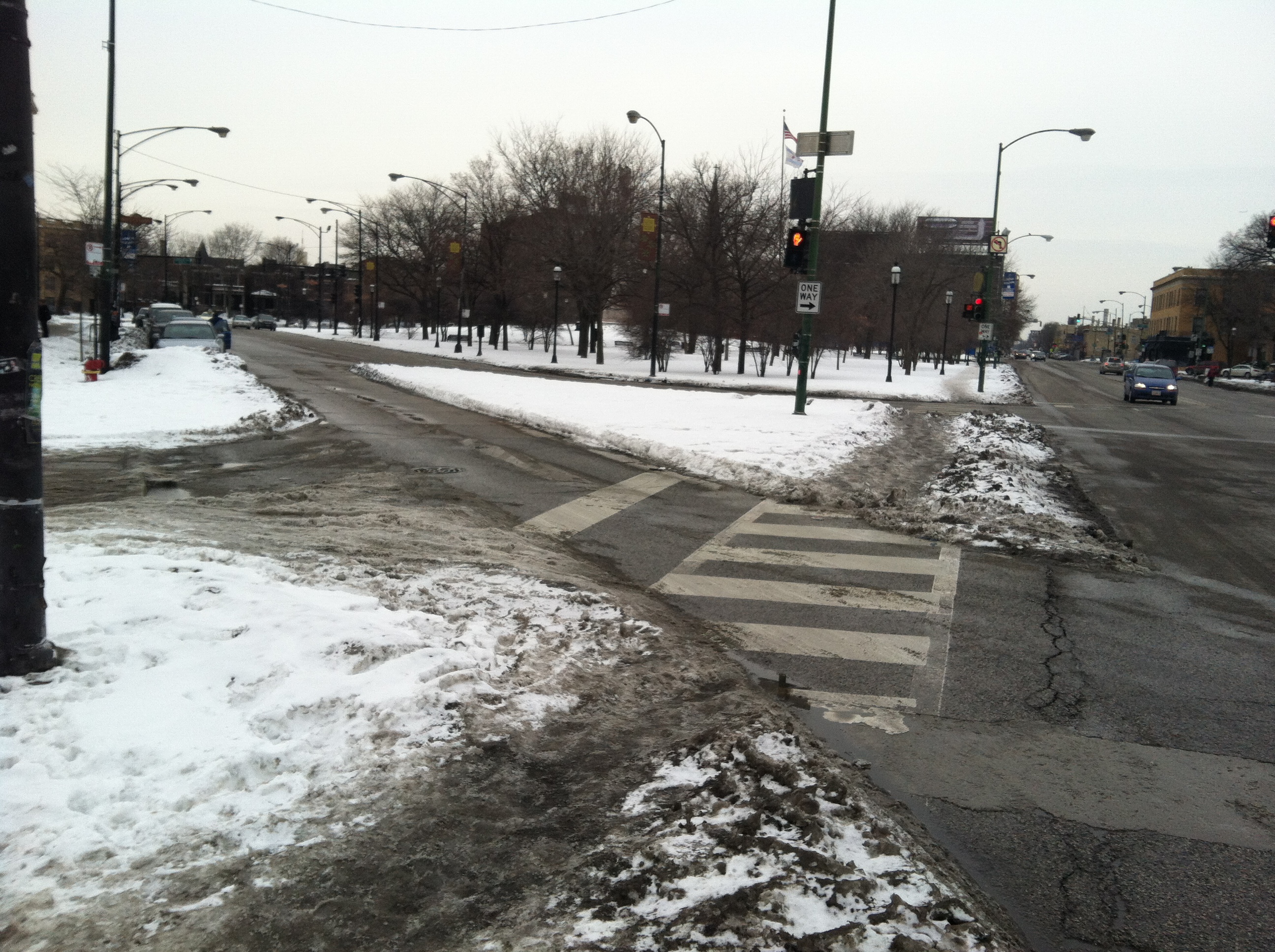
The intersection of Logan Boulevard and Western Avenue is full of safety issues. We’ve identified a number of these issues below, and will be proposing solutions in a follow-up post.

Logan Boulevard’s beautiful tree-lined landscape changes to a dark, curvy, pothole ridden, gauntlet of transportation issues as you approach its intersection with Western Avenue. All modes of travel are affected as pedestrians, cyclists, and motorists must successfully navigate many obstacles to reach their destination.
There are a lot of reasons to head east from Logan Square via Logan Boulevard.
- There’s a Target waiting for you on the other side of the highway.
- XSport fitness is just a block past the Western intersection.
- There’s a skate park directly underneath the highway.
- There’s a large movie theater adjacent to the intersection.
- It’s a direct line to Diversey River Bowl!
- There’s a Divvy Station at Logan/Elston.
- One of Logan Square’s best grocery stores is accessible via Logan Boulevard.
- It’s a direct route to the highway.
- Potbelly is located nearby. Have you had one of their milkshakes lately? They’re divine.
And there are many safety issues at the intersection of Logan and Western.
- The road curves abruptly, causing motorists to steer back and forth 4 times in a short distance.
- Potholes and poor road patches cause motorists and bicyclists to veer dangerously into the neighboring lane.
- Large highway and Metra underpasses cause disorientation while a driver’s eyes adjust to changing light conditions.
- The sidewalks and crosswalks on the South side of Logan feel unsafe while under the highway, and disappear at multiple instances resulting in a broken connection to destinations like Target.
- Logan Boulevard’s left turn lights are very short, allowing 4 cars at most to make the light. This leads to cars running the red turn light. (Especially those heading south on Western and to the highway on-ramp.)
- Cars are often parked in the bike lane, which causes them to overhang into the driving lane. This results in cyclists veering into the driving lane, and motorists swerving into the driving lane.
We also created an interactive map that calls out these points in more detail. Take a look and let us know your thoughts on this intersection’s many troubles.
http://bit.ly/logan-western-issues
Excessive Road Width Encourages Speeding into School Zones
Posted: June 25, 2014 Filed under: Alderman Deb Mell, Bicycle Infrastructure, Pedestrian Safety | Tags: anti-homeless barrier, Belmont, bike lane, Kedzie 4 Comments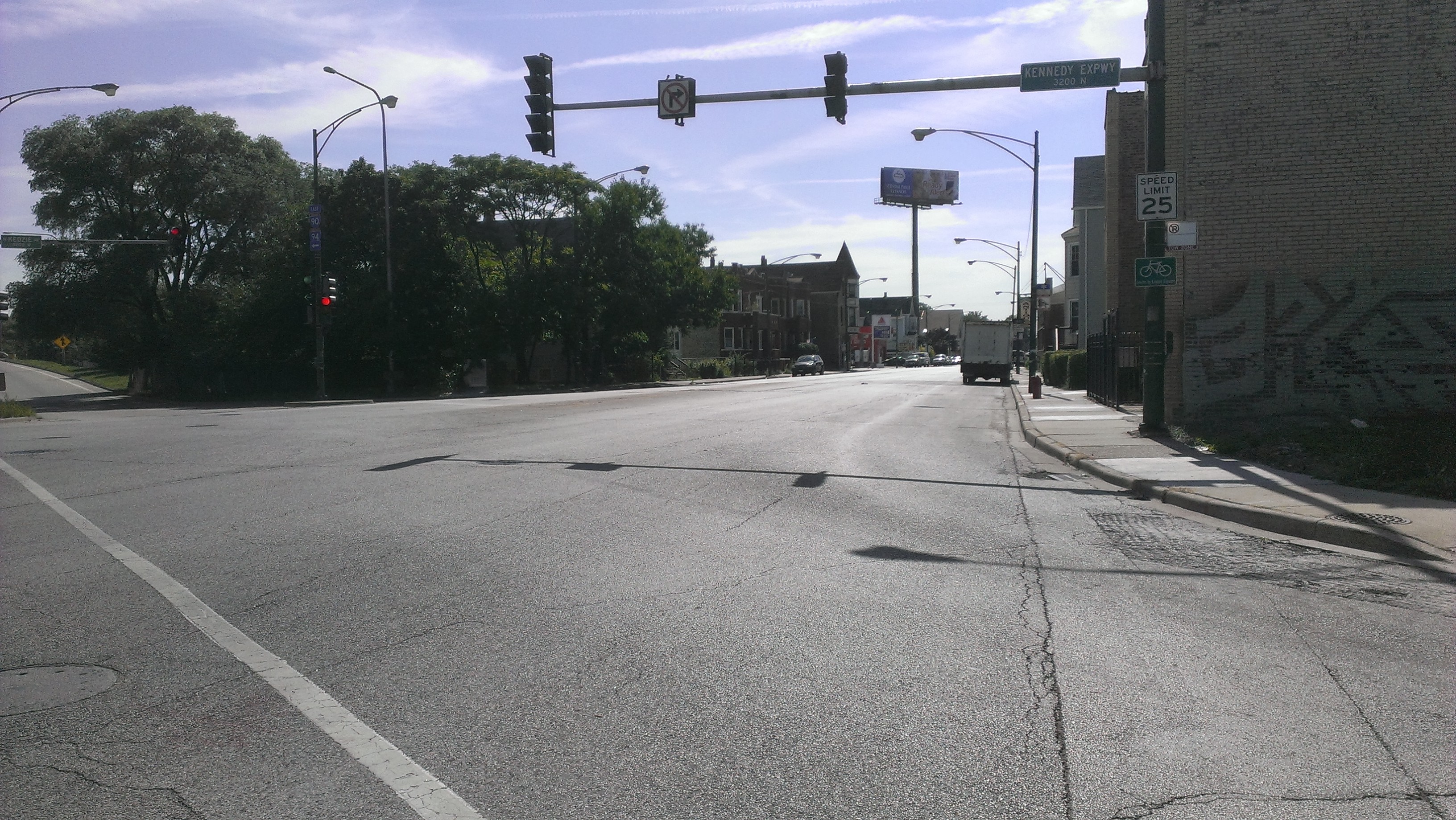
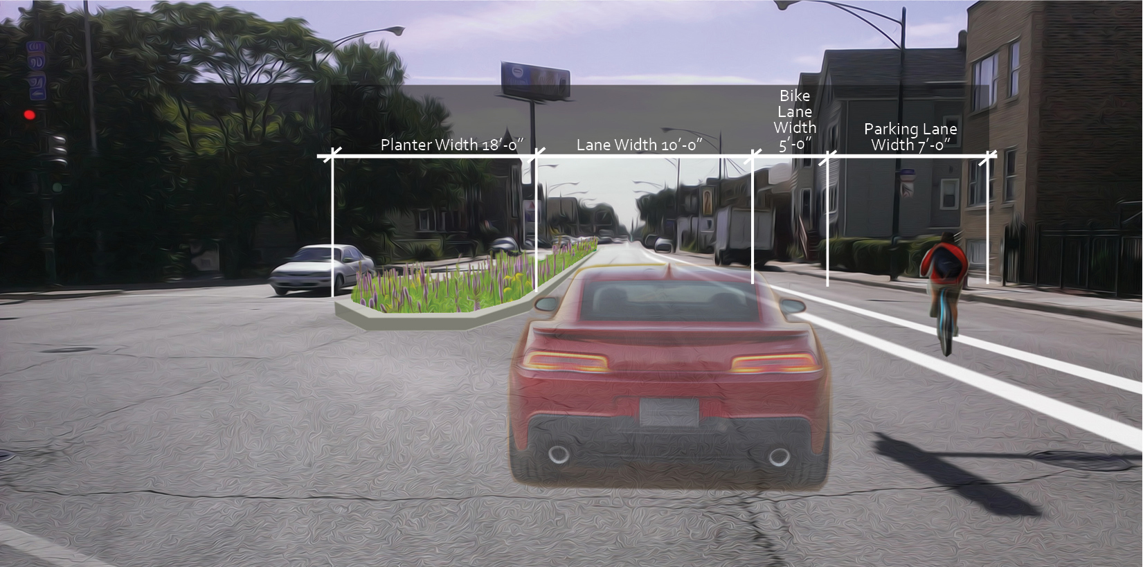
The southbound lane of traffic is currently 40′ wide. The target lane width for a main street is 10′.
Much has been said about Chicago’s desire to raise revenue and increase safety on City roads by installing speed cameras at parks and schools around Chicago. Though this maybe a short term fix, I argue here that poor roadway design encourages speeding and gives drivers the opportunity to take risks to pursue the fastest route.
The street in question here is Kedzie, beginning north of the intersection at Belmont. I live about a block away from here and from Logandale Middle School. The location is a short walk or bike ride to Jewel, Revolution Brewery, the Belmont Blue Line station, and the Belmont bus. That walk or bike ride, however, can be unsafe, unhealthy, and even dangerous. The video below shows vehicles traveling south on Kedzie where drivers are given the opportunity to pass each other on the right in an effort to beat the traffic light at Kedzie and Wellington; the northwest corner of Logandale Middle School. http://www.youtube.com/watch?v=MUdgmBgGsPw
The roadway should be designed so drivers naturally arrive at a speed that is safe for them and pedestrians. Narrowing lane widths as part of what CDOT describes as a road diet will encourage this behavior. BWLS has a series of recommendations that would increase pedestrian, bicyclist, and driver safety:
- Striping a bike lane on southbound Kedzie, 50′ north of Belmont and connecting it to the existing bike lane south of Barry.
- Constructing a planted median on Kedzie south of the Expressway to reduce the road width, slow traffic, and make it easier to cross the street at Barry.
- Pigeon proofing the viaducts above the sidewalk and regularly cleaning the sidewalks. No one should have to walk here in its current condition.
- Fixing the potholes! It’s dangerous for bicyclists and annoying for drivers.

Sidewalk is covered in pigeon excrement and is not ADA compliant.

Potential Lane Striping north of Belmont on Kedzie
Below is a concept for a new median on Kedzie, which would calm traffic and make it easier to cross Kedzie at Barry by creating a protected refuge in the middle of the street.
Potential Planted Median and Bike Lane along Kedzie; Increases safety and beautifies this gateway to Logan Square.
Recently, concrete forms have been added underneath the bridge along Belmont which eliminate the space where the homeless people camped. These ‘anti-homless’ barriers prevent people from sleeping there, but they also create a sidewalk which is not visible to the street. Because it is now a secluded space, it may increase the risk of attacks along this sidewalk. See this article in DNAinfo.
Alderman Mell has recently indicated that TIF funds will be used to create buffered bike lanes along this stretch of Kedzie which BWLS greatly supports. We recommend making the street safer for pedestrians as well.
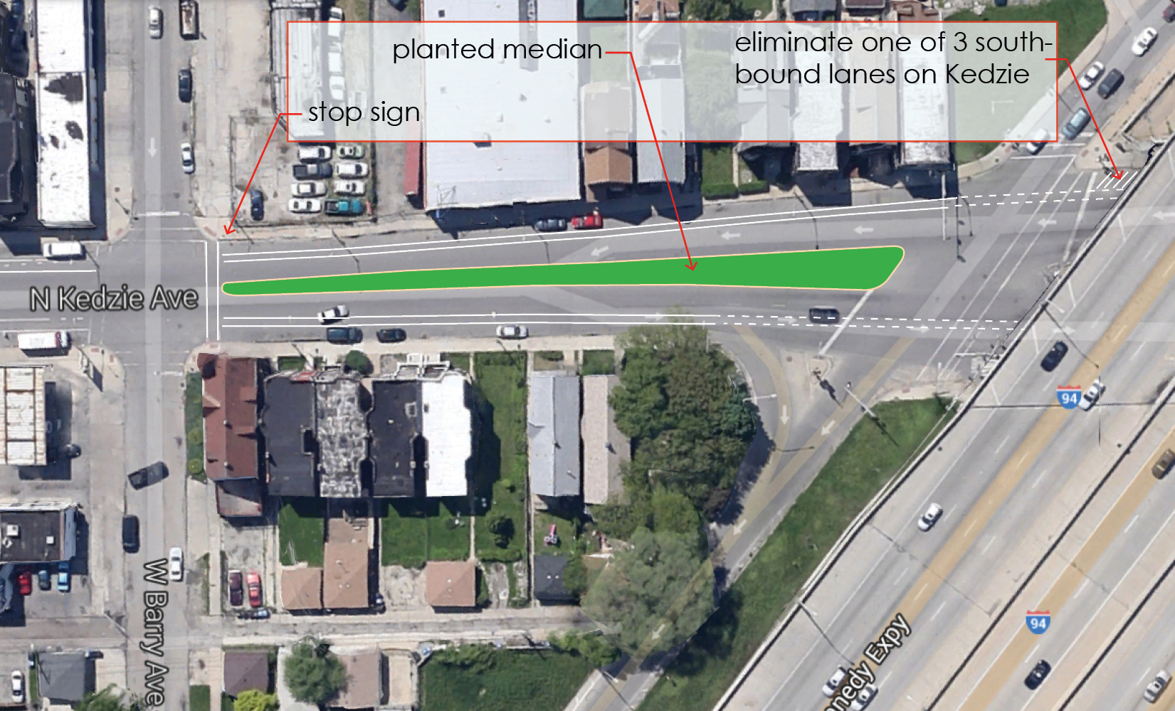
Kedzie between Belmont and Barry – Potential Improvements
Sneckdowns in Logan Square
Posted: February 17, 2014 Filed under: Logan Square Circle, Pedestrian Safety | Tags: Sneckdown 7 CommentsThe term “sneckdown” has begun creeping into public conversations about traffic calming. It is a variation on the term neckdown, also known as a curb expansion, which shrinks a street’s width, thereby giving pedestrians a safer, shorter path across. Logan Square has a prominently placed neckdown at Wrightwood Ave, just south of the Logan Square Blue Line station, which helps make Wrightwood one of the safest streets to cross around the Logan Square circle.
Sneckdowns (snow + neckdown = sneckdown) occur naturally when snow builds up, creating inadvertent neckdowns all over our city streets. The phenomenon has been hailed as a valuable (and very inexpensive) way to assess what part of a street is being used and where it is unnecessarily wide.
Bike Walk Logan Square took a few photos of sneckdowns in and around the Logan Square circle, which, despite being at the core of our neighborhood, is quite unfriendly to pedestrians. Take a look at the photos below, and imagine how much safer these streets would feel if their snowy encroachments were permanently curbed and filled with plants and decorative paving.

Facing northwest, approaching the Logan Square Blue Line, two pedestrians cross the lane for vehicles turning off Kedzie Ave onto Milwaukee Ave.

Facing south, traffic moves through the circle toward Wrightwood Ave.

Facing northwest, where Milwaukee Ave meets the southeast portion of the circle.


Facing northeast, where traffic crosses Milwaukee Ave and leaves the circle onto Logan Blvd.

New Crosswalk by the Logan Square Blue Line
Posted: September 30, 2013 Filed under: Logan Square Blue Line Station, Pedestrian Safety 1 Comment
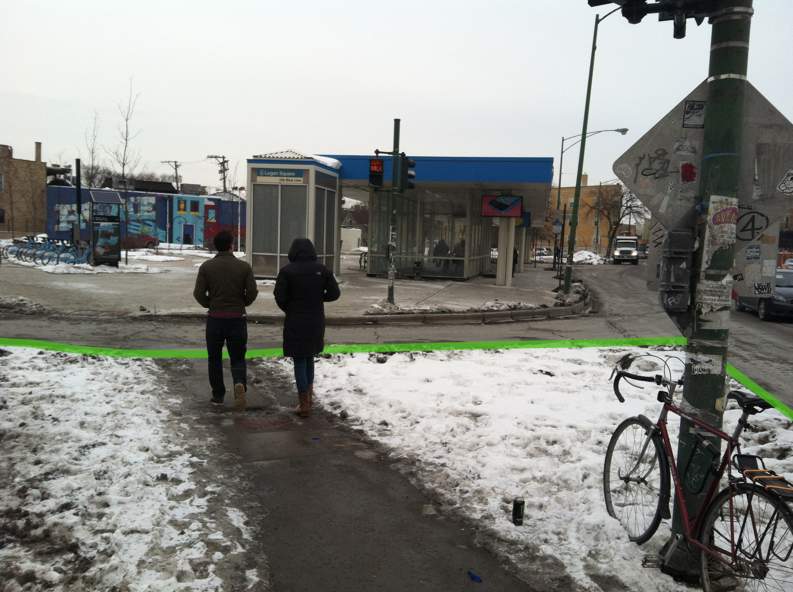
A new crosswalk was recently installed adjacent to the Logan Square Blue Line station. It crosses Kedzie Ave at the intersection of Emmett Street and Schubert Avenue. New paint clearly identifies the area as a pedestrian walkway, and a new cutaway in the center island gives pedestrians a smoother safer crossing, in addition to improving wheelchair accessibility.

Pedestrians coming from and going to the blue line station seem to be using this crosswalk more than they were before improvements were made. Drivers behavior has not changed much, however. Drivers are still unlikely to yield to pedestrians, as state law requires. It took less than a minute of observation to capture the two pedestrians pictured below, who were clearly waiting to cross, but had to wait for a gap in traffic.

A crosswalk sign in the middle of the road, reminding drivers that state law requires them to stop, would be well placed here. The pedestrian island would likely protect a sign from much of the damage other middle-of-the-road signs have been subjected to.
Although there are still a number of safety issues surrounding the Logan Square Blue Line station, Bike Walk Logan Square is thrilled to see progress being made. We have high hopes for more improvements in the future.
Logan Square Blue Line Placemaking Audit
Posted: September 10, 2013 Filed under: Logan Square Circle, Pedestrian Safety | Tags: Bike Walk Logan Square, Chicago Transit Authority, CTA, Kedzie Ave., Landscape Architecture Chicago, Logan Square, Logan Square Blue Line, Metropolitan Planning Council, Milwaukee Ave., MPC, Placemaking Leave a comment
On May 28 Bike Walk Logan Square and the Metropolitan Planning Council conducted a Placemaking Audit at the Logan Square Blue Line Station. What’s a placemaking audit? It’s a survey of the existing conditions of a place. The survey is comprised of a series of questions about:
The People

Are there people around?
Are they in groups?
What are they doing?
Are they smiling, making eye contact, do they know each other?
How old are they?
Is there evidence of volunteerism?
The Place

Is it clear what to do there?
Is it easy to get to?
Is it accessible to those with disabilities?
Is there seating?
Is it clean, does it feel safe?
Weather protection?
Ideas for Improvement
What’s good about the place now?
What would you add or change in the short, mid, and long term?
And the winner is . . .
So the members of BikeWalk Logan Square, MPC, and the volunteers in attendance discussed these questions, problems they saw, and potential lying there the whole time.

Short term ideas to make the space:
Improve the planting
Allow food trucks to use the 2nd bus lane
Invite people to bring their own chairs for meals, knitting, or a drum circle
Try pop up retail
Chalk drawings / Wayfinding
Mid Term:
Improve wayfinding (which way is north, which street is Milwaukee, and which is Kedzie)
Program a performance series, farmers’ market, craft fair, business incubator
Improve pedestrian experience and safety through crosswalk striping, signage and signal timing
Install a Chamber of Commerce merchant map, include contact information for those organizing the space so future ideas may be coordinated including art, sidewalk chaulking, planting
Increase bike rack capacity, install bike lockers, add Divvy
Partner with Chase to shovel snow from alley
Long Term:
Increase green space through better design. This could include utilizing the bus lane for seating, installing a water feature, using planting to muffle road noise
Reduce speed limit on Milwaukee and Kedzie
Alter the curb radius to slow cars turning from Milwaukee to Kedzie
The group was able to gather some great ideas and is looking for your help. What do you want the Blue Line Station to be? Let us know below!
Thanks to the Metropolitan Planning Council for leading the audit and providing pictures from the event.
Crosswalks Around the Logan Square Circle
Posted: July 28, 2013 Filed under: Logan Square Circle, Pedestrian Safety 2 CommentsNavigating the Logan Square circle as a pedestrian can be treacherous. There are a number of dangerous intersections wherein drivers often fail yield the right of way to pedestrians. While it may be appropriate to blame drivers for making dangerous decisions, poor street design often contributes to, if not causes, pedestrian hazards. Below is a comparison of the three signal-less crosswalks that surround the Logan Square circle. Comparing the characteristics of these crosswalks offers a lesson in street design as it pertains to pedestrian safety.
First, here is the crosswalk on Logan Boulevard:

The photograph faces southwest. Ahead, there is a stoplight where Milwaukee Ave. begins to cut through the circle. Eastbound drivers in the circle wait for the signal to change and then accelerate across Milwaukee, around the curve, through the crosswalk, and onto the center section of four-lane Logan Boulevard.
Almost nobody stops for pedestrians here. Notice the diagonal angle of the crosswalk, requiring pedestrians to cover more distance than would be necessary if it were perpendicular to the curb. Also problematic is its placement immediately after a corner.
Now look at this crosswalk on Kedzie Boulevard:

The photograph faces north. Drivers heading south out of the circle navigate a confusing curve before heading through this crosswalk and onto four-lane Kedzie Boulevard. Traffic moves pretty quickly through this narrow two-lane stretch, so pedestrians usually wait for a gap.
This crosswalk has some positive characteristics. The large median (partially visible on the right) allows pedestrians to cross southbound and northbound lanes separately. Also, drivers seem to be a little short on space. There does not seem to be quite enough space for two lanes of traffic, and that can have a calming effect. Still, drivers rarely yield to pedestrians here.
Lastly, here is the crosswalk across Wrightwood Avenue, on the west side of the circle:

The photograph faces southeast. Drivers leaving the circle turn west on to Wrightwood (from left to right in the photograph above). Eastbound vehicles have a stop sign to obey before entering the circle (from right to left in the photograph above). Notice the curb extensions that shorten the distance across the street for pedestrians, and also shrink the space vehicles can travel through. Another difference here is that Wrightwood is a two-lane street, whereas Kedzie and Logan have four lanes.
Drivers consistently yield to pedestrians at this crosswalk. Pedestrians confidently cross with little hesitation.
Why do so many drivers yield at Wrightwood, but so few at Kedzie and Logan? What is the most important characteristic of the Wrightwood intersection? Perhaps it is the curb extensions. Curb extensions have been shown to have a calming effect on traffic. Perhaps it is the larger number of pedestrians who use this crosswalk, many of whom are coming from the nearby train station. Or maybe the stop sign for eastbound traffic leads people to believe the right-of-way belongs to pedestrians, when in fact state law requires drivers to stop for pedestrians in all crosswalks. Or it could be Wrightwood’s two lanes compared to four-lane Kedzie and Logan.
Most likely, a combination of these characteristics and others accounts for a more friendly pedestrian intersection at Wrightwood. Fortunately, plans are being developed for a major overhaul to the Logan Square Circle. We are excited and quite optimistic that the designs will include significant considerations for pedestrian safety.

Recent Comments