Accessing The 606/Bloomingdale Trail: Drake Ave
Posted: June 5, 2014 Filed under: Bicycle Infrastructure, The 606/Bloomingdale Trail | Tags: Bloomingdale Trail, The 606 3 Comments
Image courtesy of The Trust for Public Land
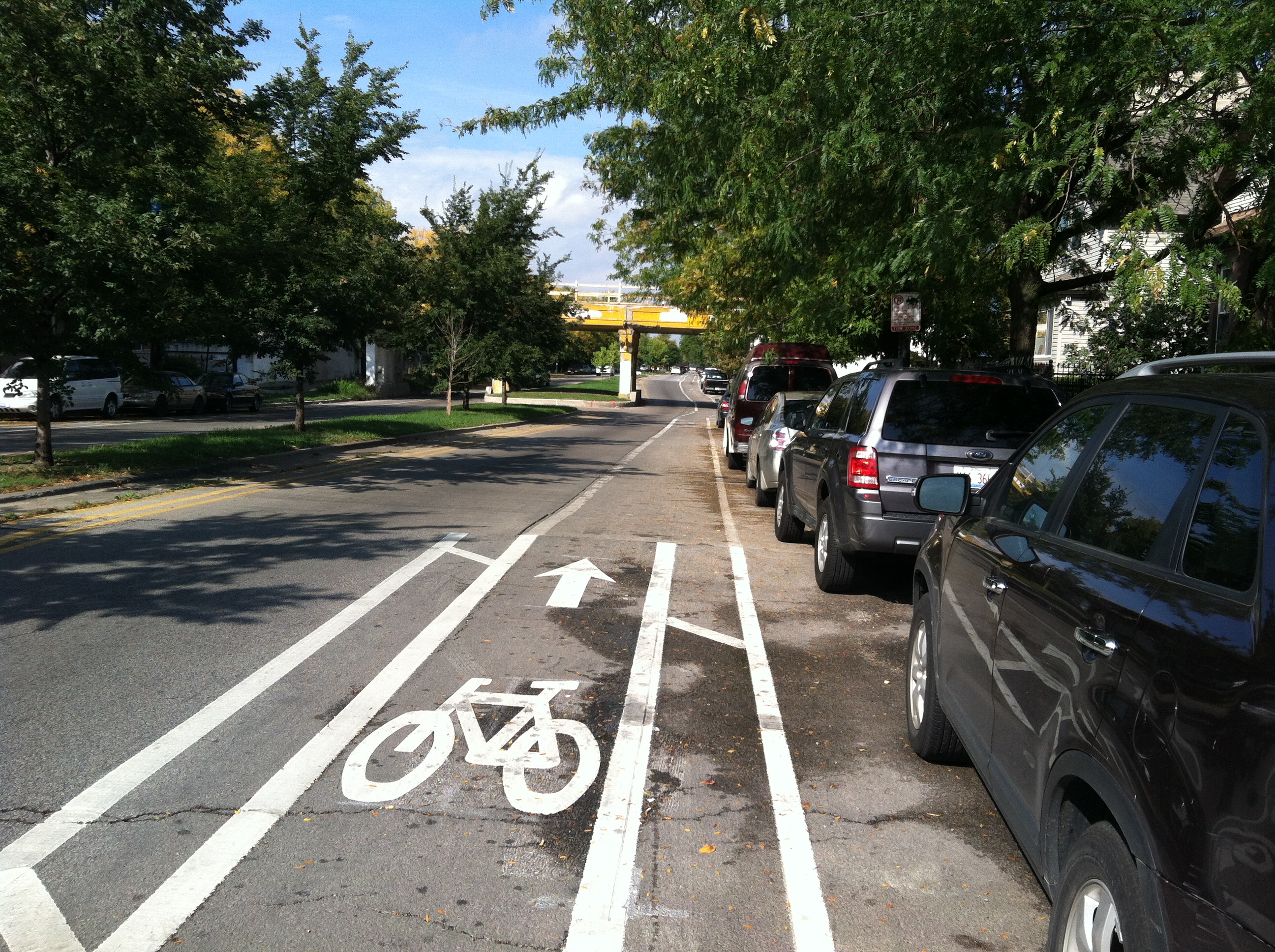
Construction continues at a rapid pace on The 606 and its Bloomingdale Trail. The trail is expected to open sometime this fall. In anticipation, we’re evaluating whether Logan Square residents will have a safe way of getting there by bicycle. Today, we take a quick look at the trail access point at Drake Ave (3550 West).
The trail will have one access point on the west side of Drake Ave. Where it crosses the trail, Drake is a one-way street pointing north. However, two blocks north of the trail, at Armitage Ave, it becomes a one-way street pointing in the opposite direction. So, whether cyclists are headed away from or toward the trail, Drake will force them to turn at Armitage or before.

The map above shows the area around the access point at Drake. The access points at Lawndale to the west and Kimball to the east are also visible. The routes in yellow are bike routes that have been proposed by the city in its Streets for Cycling 2020 Plan (pdf). Drake sits in an area between proposed bike routes — routes that will be better connected to the Bloomingdale Trail via other access points. This fact, in combination with the fact that Drake is a flip-flopping one-way street, means it likely won’t serve many cyclists.
If Drake were to become a dedicated bike route, one option would be to make it a contraflow neighborhood greenaway, similar to what is being planned for Wood St. in Wicker Park. A connection to Palmer St — which is an important proposed east/west bike route half a mile north of the trail — would be valuable. However, it may make more sense to focus on the bike routes to the west and east (Lawndale Ave, Spaulding Ave, and Sawyer Ave) that are part of the Streets for Cycling 2020 Plan.
Contact your alderman and tell him/her that you’re excited about The 606, and want to be able to access it safely. Ask him/her to ensure that Lawndale, Spaudling, Sawyer, and Palmer become dedicated bike routes in keeping with the Streets for Cycling 2020 Plan.
Here is a map of Logan Square wards, including the 1st Ward (Joe Moreno), 26th Ward (Roberto Maldonado), 30th Ward (Ariel Reboyras), 31st Ward (Ray Suarez), 32nd Ward (Scott Waguespack), 33rd Ward (Deb Mell), and 35th Ward (Rey Colón).
An Open Letter Regarding Bike Lanes on Elston Ave
Posted: March 30, 2014 Filed under: Bicycle Infrastructure | Tags: Elston Ave 3 CommentsAlderman Waguespack and Alderman Fioretti,
We, the members of Bike Walk Logan Square and Bike Walk Lincoln Park, wish to impart to you our support for the improvement of bicycle infrastructure on Elston Ave, north of North Ave. A number of business leaders in the Elston Corridor Planned Manufacturing District have opposed the installation of any type of bike lanes. Our evaluation of the surrounding bike network clearly indicates that Elston must become a prioritized bike route.
Elston is a very direct route to and from downtown, and there are currently traditional bike lanes striped along the entire length of Elston. As such, many cyclists consider it one of their safest and fastest options. A large number of cyclists use Elston on a daily basis. Any effort to downgrade the level of safety for cyclists on Elston would be not only egregiously neglectful of cyclists’ safety. It would also be ineffective at significantly deterring cyclists from riding on Elston.
Milwaukee Ave, which has been proposed as an alternative route, would be an insufficient replacement. Elston and Milwaukee are separated by about a mile for most of their length, which is much too large a detour for cyclists. The Kennedy Expressway presents another issue. It divides the two bike routes, and there is a shortage of safe bikeways underneath the Kennedy. Thirdly, Milwaukee Ave is much narrower than Elston; for much of its length, there is insufficient space for any safer infrastructure than the inadequate shared bike lanes in place currently. Elston, in contrast, has more width. Another alternative to the Elston bike route has been proposed to the east, but it has similar problems; It is too indirect, it is too far from other bike routes, and it would be difficult to access from the west because of a lack of safe bike routes over the river.
We believe the safest bike infrastructure currently in place in Chicago is the barrier protected lane, which relies on a row of parked cars to protect cyclists from moving vehicles, and we believe barrier protected lanes are appropriate and necessary for bicyclists on this part of Elston. However, because this type of infrastructure is believed by some parties to have the potential to negatively affect truck traffic in and out of the PMD, an alternative has been proposed. Buffer-protected lanes are similar to traditional bike lanes in that they place bicyclists between parked vehicles and moving vehicles, but additional buffer zones are painted on both sides of the bike lane to help protect cyclists. We consider this a generous compromise — one that would improve safety for cyclists and minimally affect the movement of trucks through the PMD.
Anything less than buffered-protected bike lanes on Elston Ave would be in obstinate defiance of the city’s Complete Streets guidelines, which ensure “that our streets are safe and designed for all users.” We respectfully ask that you remain mindful of that commitment moving forward. Thank you for your time and consideration.
Sincerely,
Joe Robinson, Bike Walk Logan Square
Michelle Stenzel, Bike Walk Lincoln Park
Nicole Semple, Bike Walk Logan Square
Douglas Pettay, Bike Walk Logan Square
Nate Lynch, Bike Walk Logan Square
Michael Reynolds, Bike Walk Lincoln Park
CC:
Rey Colón
Deb Mell
Joe Moreno
Michelle Smith
Rebekah Scheinfeld
Luann Hamilton
Sneckdowns in Logan Square
Posted: February 17, 2014 Filed under: Logan Square Circle, Pedestrian Safety | Tags: Sneckdown 7 CommentsThe term “sneckdown” has begun creeping into public conversations about traffic calming. It is a variation on the term neckdown, also known as a curb expansion, which shrinks a street’s width, thereby giving pedestrians a safer, shorter path across. Logan Square has a prominently placed neckdown at Wrightwood Ave, just south of the Logan Square Blue Line station, which helps make Wrightwood one of the safest streets to cross around the Logan Square circle.
Sneckdowns (snow + neckdown = sneckdown) occur naturally when snow builds up, creating inadvertent neckdowns all over our city streets. The phenomenon has been hailed as a valuable (and very inexpensive) way to assess what part of a street is being used and where it is unnecessarily wide.
Bike Walk Logan Square took a few photos of sneckdowns in and around the Logan Square circle, which, despite being at the core of our neighborhood, is quite unfriendly to pedestrians. Take a look at the photos below, and imagine how much safer these streets would feel if their snowy encroachments were permanently curbed and filled with plants and decorative paving.

Facing northwest, approaching the Logan Square Blue Line, two pedestrians cross the lane for vehicles turning off Kedzie Ave onto Milwaukee Ave.

Facing south, traffic moves through the circle toward Wrightwood Ave.

Facing northwest, where Milwaukee Ave meets the southeast portion of the circle.


Facing northeast, where traffic crosses Milwaukee Ave and leaves the circle onto Logan Blvd.

Accessing The 606/Bloomingdale Trail: The Western Trailhead
Posted: January 22, 2014 Filed under: Bicycle Infrastructure, The 606/Bloomingdale Trail | Tags: Bloomingdale Trail, The 606 1 CommentAs work continues on one of the most exciting urban bike trail projects in the country — The 606/Bloomingdale Trail — we at Bike Walk Logan Square ask a crucial question. How will Logan Square residents get there?
Having reviewed the Streets for Cycling 2020 plan (pdf), we highlight a number of important routes that we suggest prioritizing, and we point out some gaps in the bicycle network that, ideally, ought to be addressed.
In this post, we begin at the western end of the Trail, where there will be trail access points on Ridgedale Ave and Lawndale Ave. The McCormick Tribune YMCA sits just north of the trail on Lawndale, which promises to be a popular destination for trail users. However, north and west of the trail, cyclists encounter some holes in the network.

The 606 Access at Ridgedale and Lawndale, Image courtesy of The Trust for Public Land, as presented at the public meeting on June 18, 2013.
First, Lawndale is blocked just south of Armitage Ave. Bikes can squeeze through the cuts in the curb, but a dedicated bike route (which Lawndale is in the Streets for Cycling 2020 plan) should better accommodate bicycles.
Second, Ridgeway Ave is not a bike route. It easily connects to bike routes on Cortland Ave and then Hamlin Ave. Considering the level of bicycle traffic that we expect will follow that route, it makes sense to declare Ridgeway a bike route, at least between the trail and Cortland Ave.
Third, a couple of blocks north of the trail, on the other side of Armitage, cyclists will find that there are two bike routes on one-way southbound streets (Hamlin and Lawndale). Unless one of those streets is made to accommodate northbound cyclists, bikers will have two southbound bike routes but no northbound route.

Accessing The 606 from the Ridgeway and Lawndale access points
Another important consideration is how cyclists will travel east and west when they are north of the trail. Both Palmer St. and Wrightwood Ave. are slated to become bike routes extending through the neighborhood (and much further west). Both have been suggested as possible neighborhood greenways (similar to Berteau Ave on the north side). And both will be important for many Logan Square residents to safely access the trail on bike. It is therefore critical that bike infrastructure on Palmer and Wrightwood be well implemented.

Streets for Cycling 2020- West Logan Square
Our recommendations have been sent to the Chicago Department of Transportation, with support from Alderman Rey Colón. A handful of wards intersect at or near The 606. They include the 1st Ward (Joe Moreno), 26th Ward (Roberto Maldonado), 30th Ward (Ariel Reboyras), 31st Ward (Ray Suarez), 32nd Ward (Scott Waguespack), 33rd Ward (Deb Mell), and 35th Ward (Rey Colón). This map of Logan Square wards can help you see where you are and which wards you will travel through on your way to The 606. Please consider contacting your alderman to tell him or her that you want safe access to The 606 for bicyclists and pedestrians.
The 606 will surely be a wonderful addition to our neighborhood. Let’s do what we can to make sure our neighbors can get to it safely. And let’s hope it sparks a web of complete streets infrastructure that reaches into Logan Square and beyond.
Impending Improvements on California Ave
Posted: November 6, 2013 Filed under: Bicycle Infrastructure 5 Comments
Intersection of California and Altgeld, Facing Southeast
On October 17th, a group of concerned neighbors met with First Ward Alderman Proco “Joe” Moreno at Letizia’s Fiore, 2456 N California Ave. The meeting was hosted by Letizia’s co-owner Fabio Sorano. Sorano has led the charge to improve dangerous traffic conditions at the intersection of California Ave and Altgeld St, outside of where his business sits.
The stretch of California Ave between Logan Blvd and Fullerton Ave (one block north and south of Altgeld, respectively) currently has rush hour parking restrictions in place. This means that during the morning and evening rush hours, parking is prohibited on one side of the street, thereby allowing automobiles to move in two northbound lanes in the morning and two southbound lanes in the afternoon (toward and away from the Kennedy expressway, respectively).
Pedestrians crossing California here face considerable danger. Drivers rarely stop for pedestrians, as the law requires. Conditions are especially bad when the rush hour parking restrictions are in effect, but the intersection remains dangerous throughout the day.
Unfortunately, the presence of rush hour lanes rules out a number of potential infrastructure projects that would improve pedestrian safety. Stop signs, middle-of-the-road pedestrian signs, curb bump-outs, and bike lanes are all prohibited here by CDOT guidelines because of the presence of rush hour lanes.
However, the neighbors who gathered at Letizia’s were pleased to hear Alderman Moreno announce that an ordinance has already passed the city council which will remove rush hour parking restrictions on California Ave, between Logan Blvd and Fullerton Ave. In addition, Moreno has agreed to use his ward’s 2014 menu funds to install traditional bike lanes on this stretch of California. Both moves warrant praise, as they will significantly improve safety for pedestrians.
As for bicyclists, we encourage Alderman Moreno to partner with CDOT to implement the safest possible street design. California Ave represents an important bike route. According to the Chicago Streets for Cycling 2020 Plan, California is slated to become a cross town bike route through Logan Square. While traditional bike lanes (without a buffer or a barrier) will be a welcomed improvement, they will fall short of the ambitious safety goals set by the Streets for Cycling Plan. Granted, it will be a challenge to design considerably safer bike lanes on such a narrow street as California Ave. But, considering the level of demonstrated local support, perhaps this is one place where the city should find a way.
Update: the northbound rush hour lanes on California Ave are only open in the morning, and the southbound lanes are only open in the evening. A previous version of this post mistakenly declared that both lanes are open at both times.

Intersection of California and Altgeld, Facing Northeast
Education Event for Bicyclists: October 2013
Posted: October 16, 2013 Filed under: Uncategorized 1 Comment
Bike Walk Logan Square is teaming up with Active Transport Alliance to host an educational event next Tuesday, October 22, at the Logan Square library. Come learn about new laws that help cyclists, progress on The 606 (which includes the Bloomingdale Trail), and the introduction of Divvy bikes to the neighborhood!
A Tour of the New Bike Lanes on Kedzie Ave
Posted: October 10, 2013 Filed under: Bicycle Infrastructure 2 Comments
New Buffered Bike Lane on Kedzie Ave
This summer, buffered bike lanes were installed on Kedzie Ave, between North Ave (1600N) and Palmer Square (2200N). These are the first buffered bike lanes to extend into Logan Square. We are excited to see a piece of the city’s growing bicycle network in our own back yard. I recently took a ride down and back up the three-quarter mile stretch, snapping pictures and taking notes along the way.
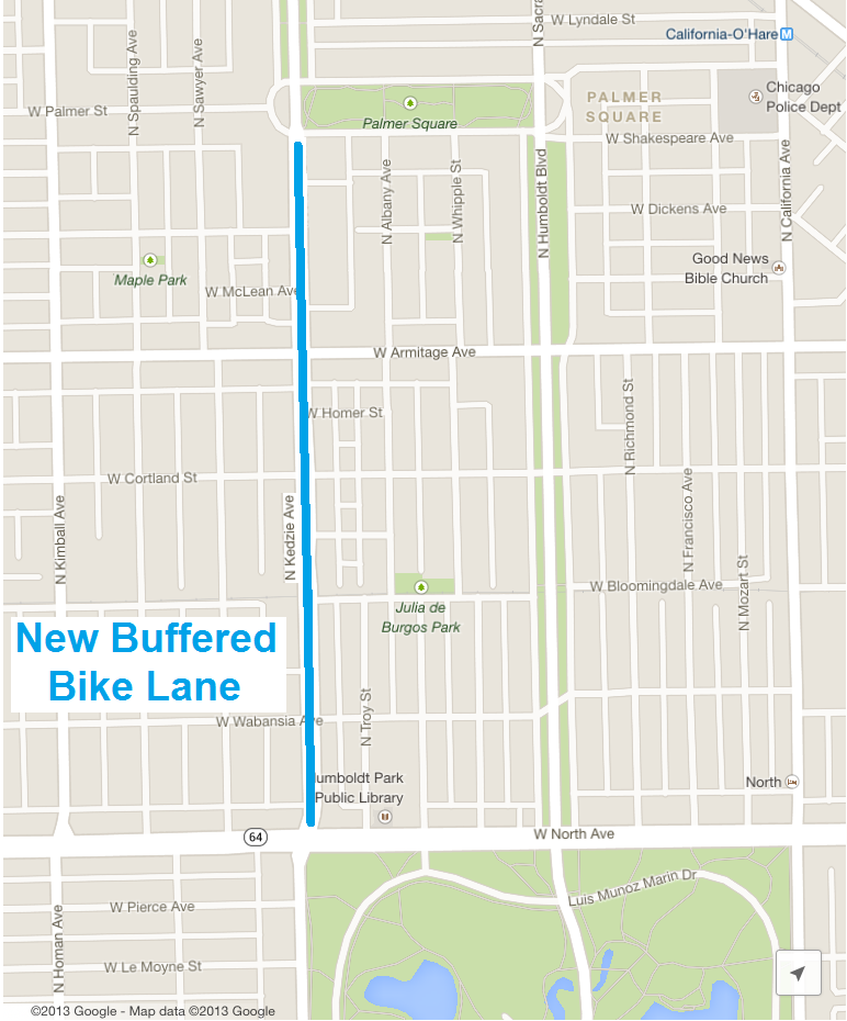
Map of the New Kedzie Ave Buffered Bike Lanes
Heading south on Kedzie, the bike lane begins beyond the intersection with Palmer Court. Anyone with experience biking in Chicago has dealt with this street design many times. The bike lane does not begin until mid-block, and it can be dangerous getting there. However, once you have reached it, the painted buffer on either side of this new bike lane provides a degree of protection from moving traffic on one side and car doors on the other. It is certainly an improvement over more traditional bike lanes.

Looking South at Kedzie and Palmer
Shortly before reaching Armitage Ave, the buffer disappears, presumably to make room for a right turn lane. This intersection has been the sight of multiple fatal bicycle accidents (ghost bikes memorialize Amanda Annis and Blanca Ocasio). Hopefully, these new bike lanes will decrease the probability of such serious accidents occurring again. In addition to providing dedicated space for cyclists, bike lanes can have a calming effect on vehicular traffic, which could mean a safer intersection for cyclists headed in all four directions, and for pedestrians.

Looking South at Kedzie and Armitage
A couple of blocks south of Armitage, the road narrows as it goes under what will soon be the Bloomingdale Trail (aka The 606). The buffered zone separating bicycles from moving vehicles disappears, and then begins again after the underpass. Parking is prohibited on either side of the underpass, mitigating the danger of opened car doors.
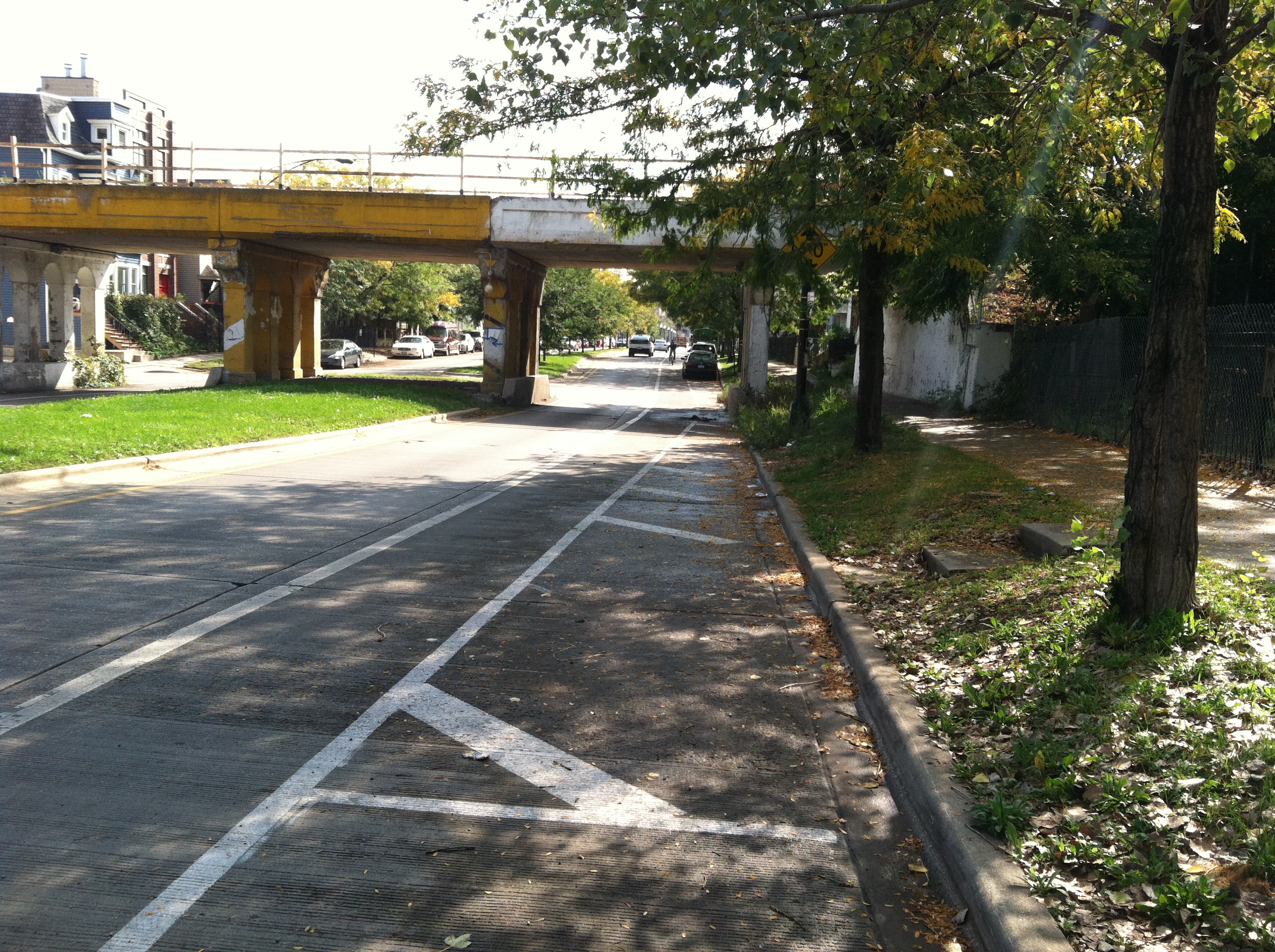
Southbound Bike Lane at Kedzie and Bloomingdale
North Ave is the southern end of the new buffered bike lanes. Unfortunately, the intersection at North Ave is wide open and treacherous. Traffic moves quickly in all directions, and there is no dedicated space for cyclists traveling through. The northwest corner of Humboldt Park is just behind the Illinois National Guard building (across the intersection on the left in the picture below), but there does not seem to be a very safe way to get there. Still, it is great to have a bike lane that almost connects to beautiful Humboldt Park.

Looking South at Kedzie Ave and North Ave
Turning around and beginning the northbound trip, the bike lane starts immediately at North Ave and the buffers begin shortly thereafter. Unlike at Palmer, where I began my tour, I felt like I had space to call my own right away. Only the traffic turning out of the gas station (off camera to the right in the picture above) felt like a threat.

Looking North at Kedzie Ave and North Ave
Once again, as I approached the Bloomingdale Trail underpass, the buffered lane disappeared. In this northbound lane, however, the buffer disappears a fair distance before parking parking is prohibited, leaving cyclists with another too familiar conundrum: whether to ride closer to moving traffic or closer to the door zone.
Northbound Bike Lane at Kedzie and Bloomingdale
The northbound bike lane at Armitage Ave is similar to the southbound lane. The buffered zones disappear before the intersection and the bike lane runs between lanes for right turning vehicles and vehicles continuing north.

Looking North at Kedzie and Armitage
North of Armitage, I encountered some very rough pavement in the bike lane. I was tossed around enough that I chose to move left and right, out of the bike lane to avoid the worst spots.

Rough Pavement in Northbound Lanes North of Armitage
The bike lane ends suddenly, before it reaches Palmer Square. Beyond the first light at Palmer Ct (ahead in the distance in the picture above), Kedzie becomes a four-lane road. Then after the second light, north of Palmer Square, Kedzie turns into a boulevard, where the outer boulevard lanes offer a fairly safe option for cyclists. It would have been nice to have the new buffered lane fully connect to that outer boulevard. Hopefully, additional bicycle infrastructure will extend further north into Logan Square soon. Chicago’s Streets for Cycling 2020 plan has Kedzie slated to become a crosstown bike route, extending north to Logan Blvd.

Looking North Approaching Palmer Ct.
Despite its flaws, the new bike lanes on Kedzie are cause for celebration. Logan Square now has its first taste of the city’s recent push for improved bicycle infrastructure. We at Bike Walk Logan Square are delighted.
New Crosswalk by the Logan Square Blue Line
Posted: September 30, 2013 Filed under: Logan Square Blue Line Station, Pedestrian Safety 1 Comment
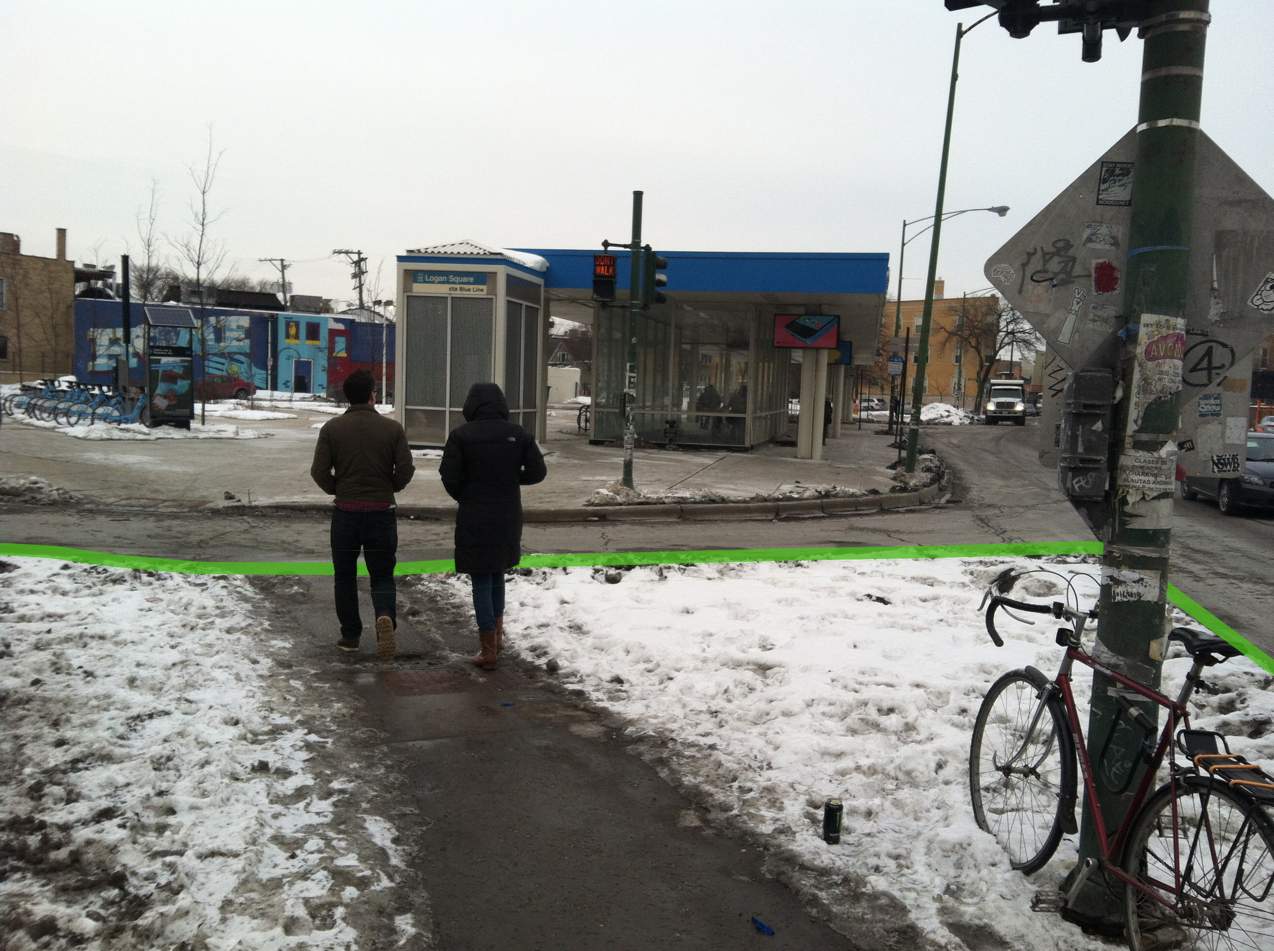
A new crosswalk was recently installed adjacent to the Logan Square Blue Line station. It crosses Kedzie Ave at the intersection of Emmett Street and Schubert Avenue. New paint clearly identifies the area as a pedestrian walkway, and a new cutaway in the center island gives pedestrians a smoother safer crossing, in addition to improving wheelchair accessibility.

Pedestrians coming from and going to the blue line station seem to be using this crosswalk more than they were before improvements were made. Drivers behavior has not changed much, however. Drivers are still unlikely to yield to pedestrians, as state law requires. It took less than a minute of observation to capture the two pedestrians pictured below, who were clearly waiting to cross, but had to wait for a gap in traffic.

A crosswalk sign in the middle of the road, reminding drivers that state law requires them to stop, would be well placed here. The pedestrian island would likely protect a sign from much of the damage other middle-of-the-road signs have been subjected to.
Although there are still a number of safety issues surrounding the Logan Square Blue Line station, Bike Walk Logan Square is thrilled to see progress being made. We have high hopes for more improvements in the future.
Crosswalks Around the Logan Square Circle
Posted: July 28, 2013 Filed under: Logan Square Circle, Pedestrian Safety 2 CommentsNavigating the Logan Square circle as a pedestrian can be treacherous. There are a number of dangerous intersections wherein drivers often fail yield the right of way to pedestrians. While it may be appropriate to blame drivers for making dangerous decisions, poor street design often contributes to, if not causes, pedestrian hazards. Below is a comparison of the three signal-less crosswalks that surround the Logan Square circle. Comparing the characteristics of these crosswalks offers a lesson in street design as it pertains to pedestrian safety.
First, here is the crosswalk on Logan Boulevard:

The photograph faces southwest. Ahead, there is a stoplight where Milwaukee Ave. begins to cut through the circle. Eastbound drivers in the circle wait for the signal to change and then accelerate across Milwaukee, around the curve, through the crosswalk, and onto the center section of four-lane Logan Boulevard.
Almost nobody stops for pedestrians here. Notice the diagonal angle of the crosswalk, requiring pedestrians to cover more distance than would be necessary if it were perpendicular to the curb. Also problematic is its placement immediately after a corner.
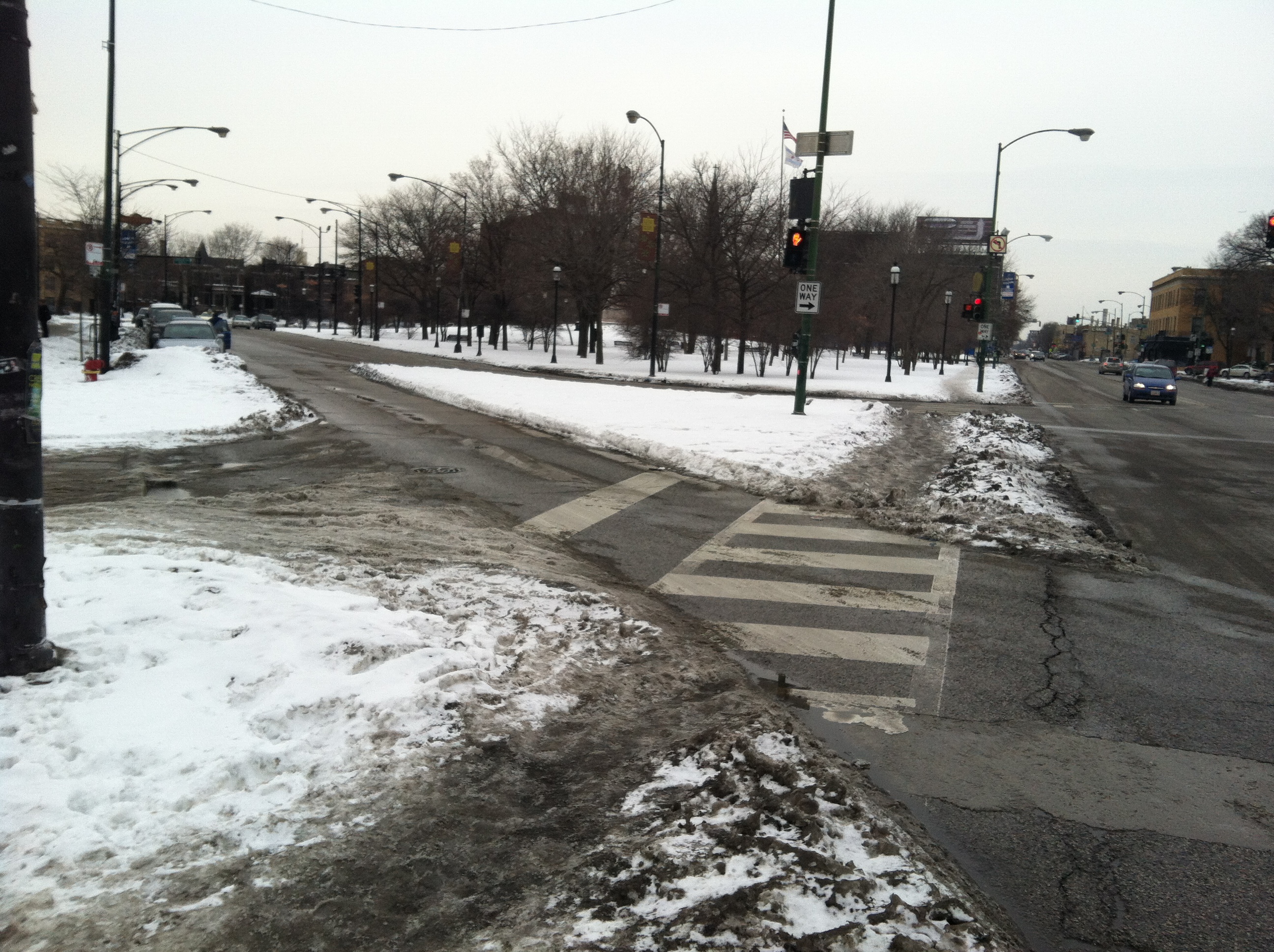
Now look at this crosswalk on Kedzie Boulevard:

The photograph faces north. Drivers heading south out of the circle navigate a confusing curve before heading through this crosswalk and onto four-lane Kedzie Boulevard. Traffic moves pretty quickly through this narrow two-lane stretch, so pedestrians usually wait for a gap.
This crosswalk has some positive characteristics. The large median (partially visible on the right) allows pedestrians to cross southbound and northbound lanes separately. Also, drivers seem to be a little short on space. There does not seem to be quite enough space for two lanes of traffic, and that can have a calming effect. Still, drivers rarely yield to pedestrians here.
Lastly, here is the crosswalk across Wrightwood Avenue, on the west side of the circle:

The photograph faces southeast. Drivers leaving the circle turn west on to Wrightwood (from left to right in the photograph above). Eastbound vehicles have a stop sign to obey before entering the circle (from right to left in the photograph above). Notice the curb extensions that shorten the distance across the street for pedestrians, and also shrink the space vehicles can travel through. Another difference here is that Wrightwood is a two-lane street, whereas Kedzie and Logan have four lanes.
Drivers consistently yield to pedestrians at this crosswalk. Pedestrians confidently cross with little hesitation.
Why do so many drivers yield at Wrightwood, but so few at Kedzie and Logan? What is the most important characteristic of the Wrightwood intersection? Perhaps it is the curb extensions. Curb extensions have been shown to have a calming effect on traffic. Perhaps it is the larger number of pedestrians who use this crosswalk, many of whom are coming from the nearby train station. Or maybe the stop sign for eastbound traffic leads people to believe the right-of-way belongs to pedestrians, when in fact state law requires drivers to stop for pedestrians in all crosswalks. Or it could be Wrightwood’s two lanes compared to four-lane Kedzie and Logan.
Most likely, a combination of these characteristics and others accounts for a more friendly pedestrian intersection at Wrightwood. Fortunately, plans are being developed for a major overhaul to the Logan Square Circle. We are excited and quite optimistic that the designs will include significant considerations for pedestrian safety.

Recent Comments